Shipping and Logistics most accurate data and tools
Purely APIs Nothing else
By trusted shipping experts
Calculate sea distances, sea routes, voyage metrics, retrieve weather forecast information, and obtain ship profile data, marine geocoding information and lots more...
Track any vessel at any time, anywhere! Constantly monitor your fleet, obtain ship historical tracks or find vessels by Destination-ETA or within a set radius from given coords.
API
AIS Positioning
API
GHG Emissions
API
Sea Routing
API
Weather
API
Geo Coding
API
Marine Maps
API
Ships Database
API
Ship Profile
Integrate our products to ...
Title 1
Use Reliable Data and only focus in developing and selling your software
Title 2
Live vessel tracking, retrieve historical tracks, find ships in proximity or per destination
Retrieve weather data for any location or a whole area, and for 67 weather variables
Title 5
Calculate voyage metrics such as distances, bunkers, voyage duration, TW, GHG CO2e
Title 6
Use our Map API to easily integrate marine maps onto any Map Library your app is using
We've got you
covered across the full cycle
Planning
Planning
Planning
Planning
Our maritime APIs support every stage of the maritime industry's workflow: from Planning sea voyages and transportation far in advance and Scheduling voyages and shipments down to each detail, to Monitoring real-time vessel-cargo activity, and Reporting any sea voyage’s or shipment’s outturn with ship tracking spanning back six years!
API
AIS Positions
API
GHG Emissions
API
Sea Routing
API
Weather
API
Geo Coding
API
Marine Maps
API
Ships Database
API
Ship Profile
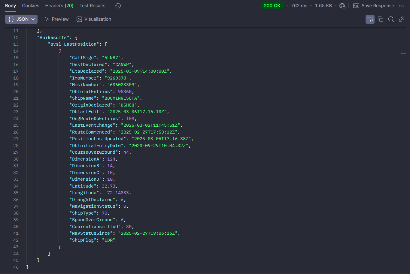
AIS
ship positions
AIS
Key features:
Global Ais Coverage
Continuosly Updated Vassel Tracking
Offering By Default Extended Ship Data And Information
Fleet Monitoring
6 Years Of Historical Tracks
Find Ships By Destination And Eta
Find Ships Within A Range/Radius From Any Coordinates
Our maritime APIs support every stage of the maritime industry's workflow: from Planning sea voyages and transportation far in advance and Scheduling voyages and shipments down to each detail, to Monitoring real-time vessel-cargo activity, and Reporting any sea voyage’s or shipment’s outturn with ship tracking spanning back six years!
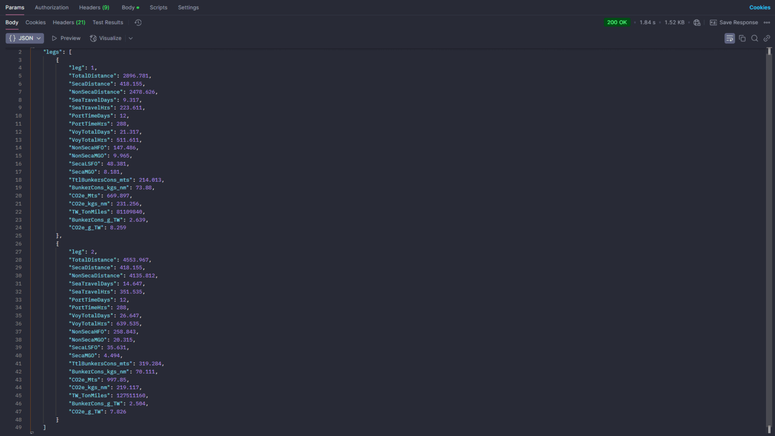
UTILIZES OUR SEA ROUTING API FOR ACCURATE AND ON THE FLY ROUTE CALCULATIONS
BUNKER CONSUMPTION BREAKDOWN
TRAVEL TIME BREAKDOWN
PORT IDLE/WORKING TIME BREAKDOWN
SECA/NON-SECA MILEAGE AND CONSUMPTION
DETAILED BUNKERS-EMISSION METRICS
COSTS THE SAME AS THE SEA ROUTING API
NavAPI’s Voyage Metrics API acts as a lightweight voyage estimation tool. It builds on our Sea Routing API, using dynamically calculated routes to deliver detailed voyage metrics and estimation data. For each voyage leg, it reports fuel consumption (FO/GO, SECA and non-SECA fuels), sea travel time, port idle and working times, and basic emissions data, while also accounting for weather delays. All results are delivered in a single API response. It is priced the same as the standard Sea Routing API and is an excellent tool for quickly and accurately obtaining voyage data.
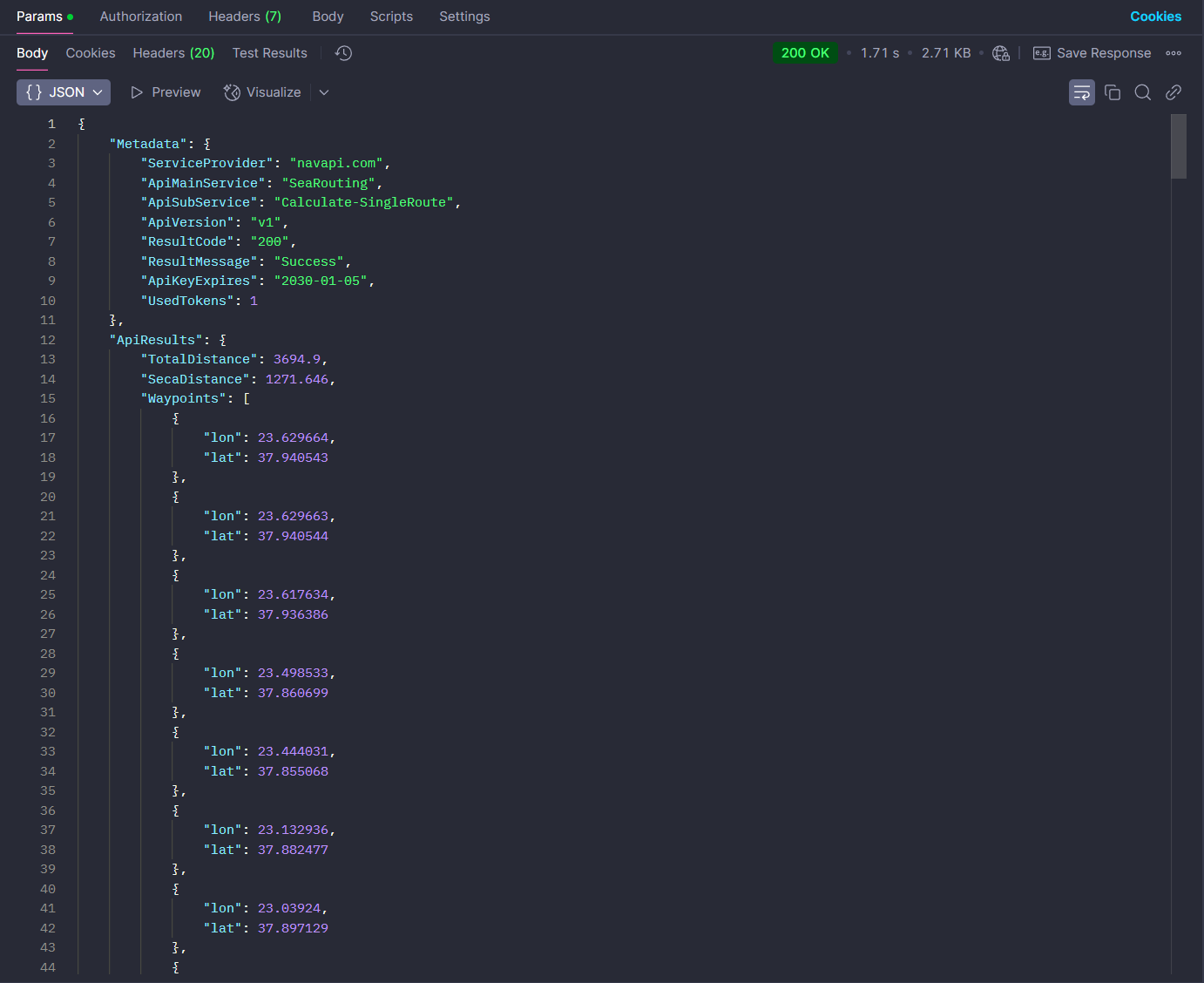
Our Sea Routing API offers the precision and flexibility needed for reliable nautical distance calculations, voyage estimation, sea travel planning, and scheduling. It is ideal for simulating real-world sea routes, Route-to-go, estimating freight costs, calculating emissions, investigate deviations, monitoring fleet ETAs, managing daily ship operations, matching ships with cargo, and more. With support for both open sea and inland routing, this API is a precise and versatile solution for a wide range of maritime and logistics applications.
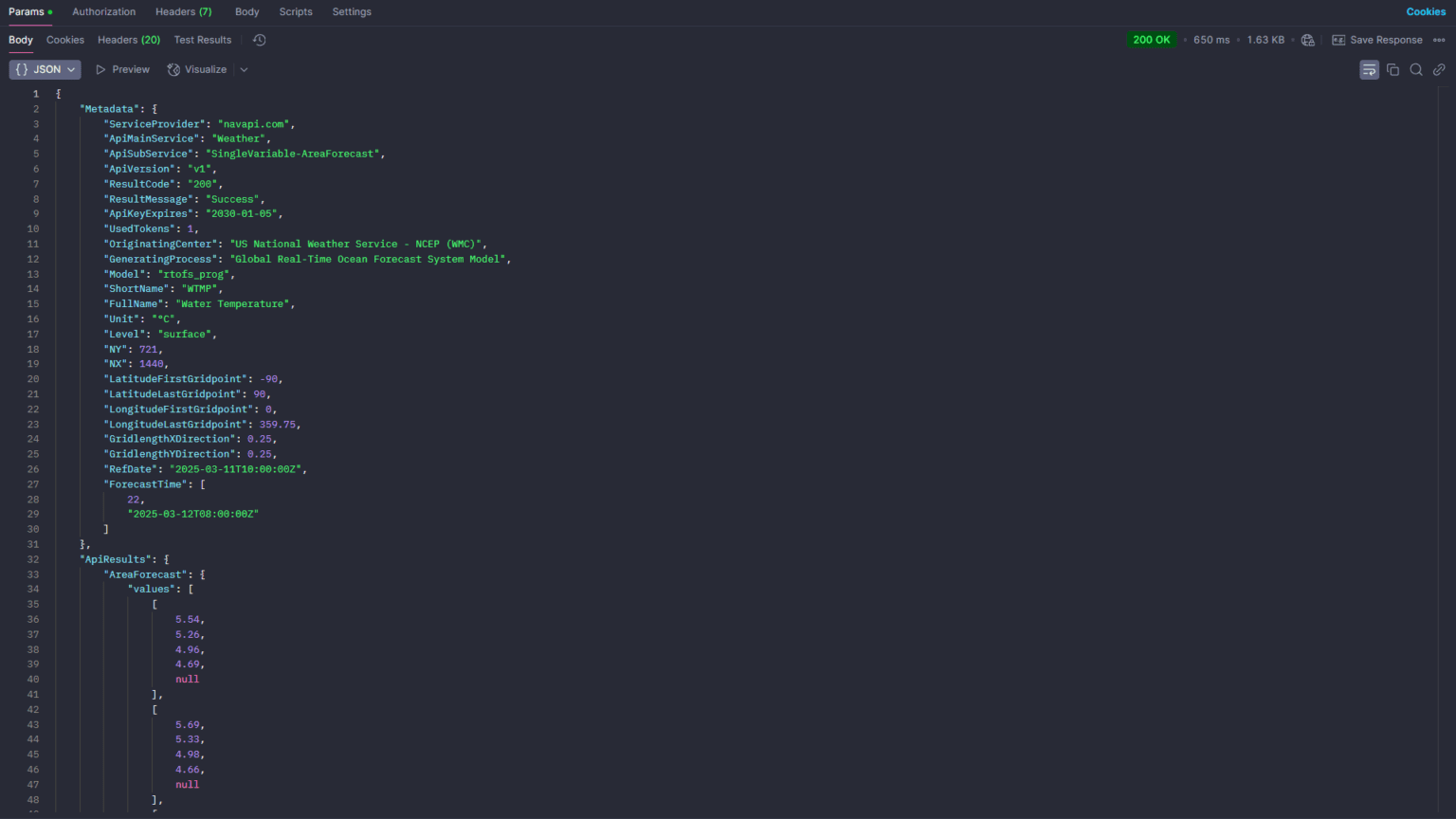
COMBINE WITH SEA ROUTING TO OBTAIN WEATHER ALONG THE ROUTE
Be aware of weather conditions with accurate forecasting models at any coordinate and across multiple surface and atmospheric levels. Retrieve detailed 10-day predictions, use versatile endpoints offering multiple variables and time steps suitable for meteograms, animated maps, customized visualizations, and tailored insights, and leverage precise astronomical data for effective operational scheduling and informed decision making. This API can also be combined with the Sea Routing API to provide weather along the route information.
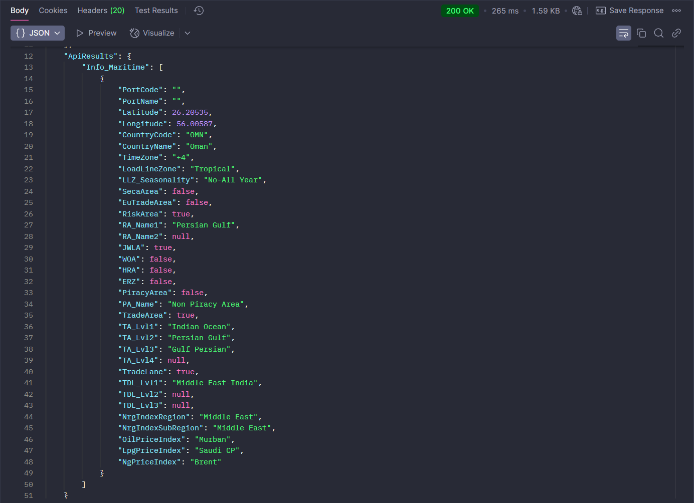
NavAPI’s Marine Geocoding API provides valuable location intelligence for any global port or coordinate. It includes Time Zones, Load Line Zones, Sea and Trading Areas, High Risk and Piracy Zones, Trade Lanes, SECA and Non-SECA zones, EU regulatory information for ETS, and Bunker Index areas. Use it to better estimate costs, address compliance requirements, and evaluate safety and operational factors. This API supports accurate freight estimation, voyage planning, activity based emission calculations, ship area awareness, and informed decision making.
WORKS WITH ANY MAP LIBRARY (LEAFLET/ GMAPS/ BING/ OPENLAYERS/ MAPLIBRE ETC.)
7 BASEMAPS
15 MAP LAYERS
DEDICATED SEAMARKS LAYER
REGULAR UPDATES
WHITE LABELED
FAST RENDERING WITH CLOUDFLARE CACHING AND INTELLIGENT TRAFFIC GEO STEERING
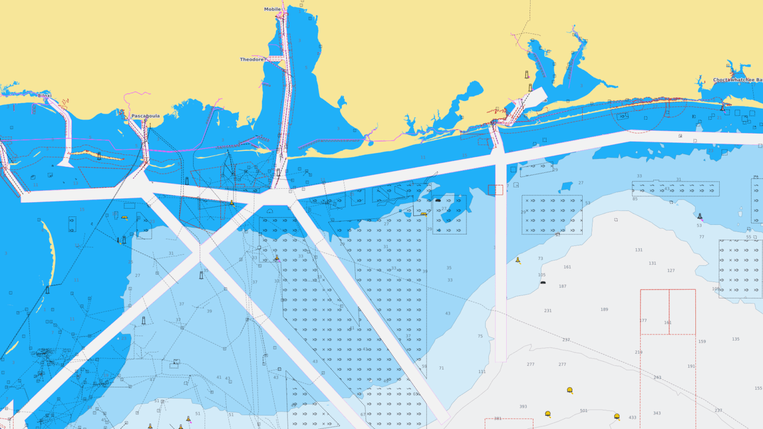
NavAPI's Marine Maps API offers a variety of basemaps and dedicated maritime layers, including sea ports, SECA areas, MARPOL areas, Load Line Zones, time zones, sea marks, risk and piracy areas, Nordic Plan Areas, Captain of the Port Areas, International Navigating Limits, and more. Easily integrate these regularly updated maps into your applications to visualize essential maritime data, simplify voyage planning, and improve compliance and operational decisions. All included in a single unlimited-use bundle with fixed annual pricing.
WORKS WITH ANY MAP LIBRARY (LEAFLET/ GMAPS/ BING/ OPENLAYERS/ MAPLIBRE ETC.)
7 BASEMAPS
15 MAP LAYERS
DEDICATED SEAMARKS LAYER
REGULAR UPDATES
WHITE LABELED
FAST RENDERING WITH CLOUDFLARE CACHING AND INTELLIGENT TRAFFIC GEO STEERING
NavAPI's Marine Maps API offers a variety of basemaps and dedicated maritime layers, including sea ports, SECA areas, MARPOL areas, Load Line Zones, time zones, sea marks, risk and piracy areas, Nordic Plan Areas, Captain of the Port Areas, International Navigating Limits, and more. Easily integrate these regularly updated maps into your applications to visualize essential maritime data, simplify voyage planning, and improve compliance and operational decisions. All included in a single unlimited-use bundle with fixed annual pricing.